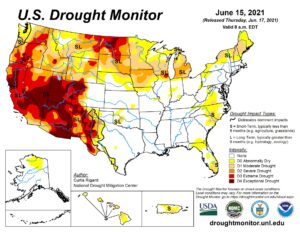
The news of the disastrous drought and extreme heat in the western United States (US) have local folks wondering if Indiana might be next. The latest release of the US Drought Monitor map (Figure 1) shows the exceptional drought in the western states as well as the expansion of extreme and exceptional drought in the north-central U.S. Currently, the lower Midwest states (that includes Indiana) seem to have been moderately spared and shorter-term forecasts and climate outlooks are suggesting relatively regular rainfall relief over the next several weeks. It is still early in the growing (and warm) season, so a drought in Indiana is not out of the question. However, the rest of June appears to be likely to receive above-normal precipitation. Combine this chance with the likelihood of above-normal evapotranspiration rates, Indiana is unlikely to gain too much ground in replenishing groundwater or surface water supplies. Figure 2 shows the additional precipitation needed (in inches) to bring the Palmer Drought Index to within normal ranges for this time of the year. With the exception of southeastern Indiana, the rest of the state needs anywhere from a little bit of rain (i.e., a trace) to as much as 9 inches (northern counties). That is a lot of rain needed for northern Indiana – particularly for an area of the state that already has below-normal groundwater levels and irrigates the most.
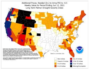
Figure 2. Modeled estimates of how much precipitation (inches) would be needed (by climate division) to return the Palmer Drought Index to normal ranges.
The 3-month climate outlook (representing July through September) is slightly favoring above-normal temperatures over that period as well as slightly favoring above-normal precipitation (Figure 3). Because the outlooks are only “slightly” confident, assume there is a bit of uncertainty on how the season will actually turn out, let alone how the timing of these conditions will occur. For example, the precipitation climate outlooks could prove to be accurate by the end of September when looking at the 3-month precipitation total. However, most all of that rain could have fallen in early July, leaving the rest of the 3-month period predominantly dry and therefore contributing to drought conditions.
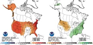
Figure 3. Climate outlooks for the July-August-September period for temperature (left map) and precipitation (right map). These are produced by the national Climate Prediction Center and illustrate confidence of favoring above- or below-normal conditions.
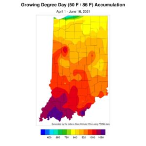
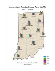
While modified growing degree day (MGDD) accumulations (Figure 4) continue to increase (what happens throughout the warm season), it is interesting how they still seem to be lagging the climatological average in the southern half of the state. The magnitude of how much behind those accumulations are seem rather insignificant compared to the seasonal totals thus far, but still noticeable on departure maps (Figure 5). Northern county MGDD accumulations are slightly above the 1991-2020 climatological average, however, lagging compared to the 2017 and 2018 seasons (Figure 6). Warm temperatures are expected over the next several days which may help increase those accumulations closer to normal, however the nature of modified growing degree days is that any daily maximum temperature above 86°F is modified down to the 86°F value. Therefore, warm days exceeding this maximum threshold do not increase MGDD accumulations at a faster rate.
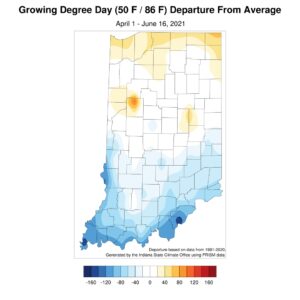
Figure 5. Modified growing degree-day departures as of 17 June 2021 compared to the 1991-2020 climatological average.
