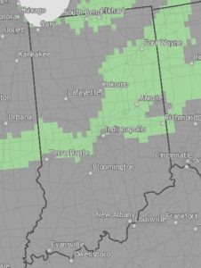
It got my attention recently that the newest USDA planting map is shifted northward compared to the one before. The planting map is based on the coldest winter temperatures of the past 30 years’ record. The most recent map is generated from data in 1981-2010, the prior one is based on data from 1971-2000. Planting zones were changed from Zone 5 to Zone 6 in several places in middle and northeast Indiana. In the map before, green areas are where planting zones have been changed. Undoubtedly, these changes will make a difference in plants that could survive in these areas in the winter. It may also affect vegetable production in the state, especially winter and protected cultural productions. Want to know which zones you are located? Check this site http://noaa.maps.arcgis.com/apps/MapSeries/index.html?appid=5f617f338eb5431eb3700e8685eccaf7

