An old saying predicts that March will go out “like a lamb”. Another saying predicts April’s wetness with “April showers bring May flowers”. A lot seems to have happened across Indiana since April began, but March finished the month with below-normal rainfall (except for the northern counties) and above-normal temperatures. Does this describe conditions that are “like a lamb”? I’ll let ‘ewe’ decide!
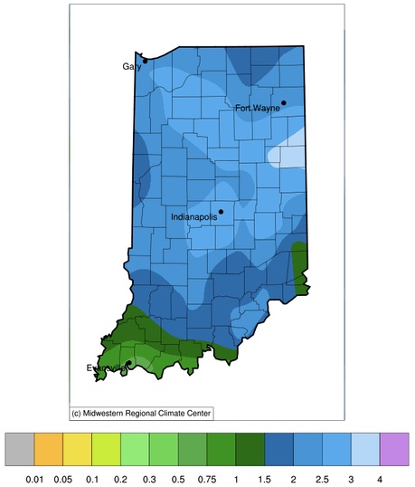
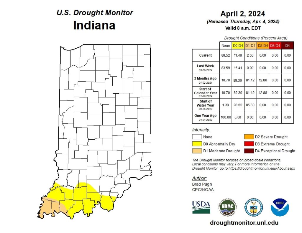
And then came April. We are less than a week in, and already, some parts of Indiana have received more than 750% of what is normal for early April. That is not a typo! Actual amounts have ranged from just below an inch of water in southwest and far southeast Indiana along the Ohio River to over three inches around the eastern counties of Adams and Jay (Figure 1). Typical rainfall for the entire month of April (averaged from 1991-2020) ranges from just 0.2” to less than 0.75”. Can we really call what we’ve seen in just the first few days April “showers”? Streams are flooding across the state, soil moisture percentages have increased significantly, and many are hoping for just a few dry days for things to calm down a bit. The U.S. Drought Monitor has eliminated abnormally dry conditions across most of the state except for southwestern counties. The far southwestern counties are considered in Moderate Drought (Figure 2). And then there are the temperatures. True, April is part of the transitional season, where one day, the temperature can be in the 70s, and the next is a chilly 30s, with light snow falling. Much of Indiana was already seeing some snow flurry activity on April 3rd after the heavy rainfall events passed through. Will that be the last of our snow events for the season, or can we expect a few more? The Midwestern Regional Climate Center has a Snowfall Climatology Toolbox (https://mrcc.purdue.edu/resources/climateTools/snowfallclimatology) where users can look up the last date of measurable snowfall for a nearby station. According to this product, since 1991, the average last date of snowfall measuring at least 0.1 inches has occurred sometime in March (with a few stations far north indicating April 1st or April 3rd). However, the latest dates have occurred in late April to mid-May. Will 2024 set a new ‘last date of measurable snowfall’ record since 1991?
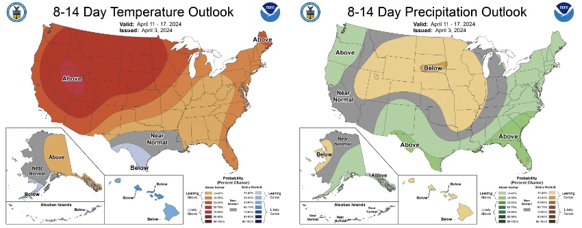
According to the National Climate Prediction Center, climate outlooks over the next two weeks are favoring above-normal temperatures, with the next 6-10 days favoring above-normal precipitation, while the 8-14-day outlook is favoring near-normal precipitation (Figure 3). Hopefully, this means very little chance of measurable snowfall over the next few weeks. The monthly climate outlook for April continues to support those trends, with the highest probability of above-normal precipitation occurring across central Indiana. Please keep in mind, though, that short-term freeze events can still move through fast enough that climate models are unlikely to predict them. Similar to the MRCC’s Snowfall Climatology Toolbox, the MRCC has another tool, the Freeze Date Tool (https://mrcc.purdue.edu/freeze/freezedatetool), where users can select a temperature threshold and statistical value (e.g., earliest, average, latest) for the date when the last spring freeze occurred since 1950. For example, across much of Indiana (except for southwestern counties), the latest date of a 28-degree freeze occurred on May 9th (the “Mother’s Day Freeze Event of 2020”).

Figure 3. The 8-14 climate outlooks for April 11-17 for temperature (left) and precipitation (right). Note that shading indicates the probability of above-, near-, or below-normal conditions occurring and not necessarily the magnitude of that departure from normal.

