After a drier-than-normal July, recent rains have put Indiana on notice for above-normal precipitation. Just two weeks into August, there was enough precipitation to cover the month’s typical August rainfall, and then some. Much of the state received over 400 percent of normal precipitation for the first two weeks of the month, and some locations east of Indianapolis received over 600 percent of normal August rainfall. Only in far southern and southwestern Indiana was precipitation near or below normal as of August 15.
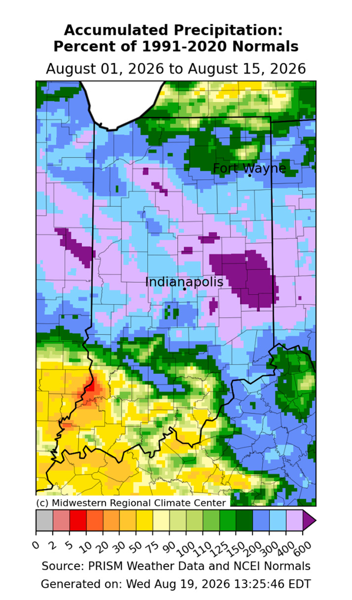
Figure 1: Percent of normal, accumulated precipitation for Indiana for August 1-15. Blues and purples indicate precipitation that is well above normal.
The heaviest impacts were felt across central and northern Indiana. Indianapolis, Crawfordsville, Lafayette, Kokomo, Richmond, Columbus, Anderson, and Muncie were among the locations affected by heavy rainfall. Indianapolis normally receives 3.2 inches during August but had already recorded 5.32 inches by August 19, making it the city’s wettest August in 10 years with 13 days remaining.
Henry County was an especially notable rainfall hot spot. Several locations received more than 11 inches in less than two days. A report near New Lisbon measured 11.50 inches, while two stations near New Castle measured 11.24 and 11.23 inches. New Castle 3 SW received 7.74 inches on August 12, breaking its previous single-day record of 4.15 inches set in 1992. By August 17, the station had received 15.35 inches for the month, making August 2026 its wettest month of any month since records began in 1950. Muncie also recorded 5.99 inches on August 12, its second-highest single-day total since 1946.
Repeated rounds of rain from August 11-17 produced widespread flash flooding and pushed several rivers into major flood stage. The White River at Anderson and Noblesville surpassed record crests set in 1913, while the river at Nora reached its highest level since that historic flood. Evacuations and water rescues occurred across central Indiana, including more than 350 evacuations in Delaware County.
In Henry County, a culvert beneath Riley Road washed out, taking part of the road with it. State Road 3 became impassable in places, with waist-high water reported in New Castle. Flooding also damaged I-70 in Wayne County and destroyed a bridge on Hazel Dell Parkway in Carmel. By August 18, 19 counties had issued local emergency declarations.
Flooded and muddy fields also created problems for agriculture. Prolonged ponding can stress crops, increase erosion and nutrient loss, and raise concerns about diseases such as stalk rot in corn. Although the water has begun receding in many areas, repairs, cleanup, and agricultural impacts will continue well beyond the rainfall event.