I couldn’t think of a better title this week, thanks to the hot weather we’ve been experiencing and the song by Arrow. While some people enjoy the heat and humidity, I must admit that I don’t find it overly pleasant. Over the past few days, average temperatures have ranged from 6 to 13°F above normal, accompanied by increased air moisture. This combination of heat and humidity has triggered summer pop-up showers across the state, resulting in localized heavier rainfall. GRANGER 1.8 ENE, located in St. Joseph County, measured 7.03 inches of rain from June 18-25. The next closest was PLYMOUTH 2.5 WSW in Marshall County with 3.98 inches.
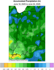
Figure 1. Accumulated precipitation June 18 to June 24, 2025.
Growing degree days (GDD) have trended upward due to the warmer weather. This is visible in the Corn GDD tool on the MRCC website. In recent days, our GDD accumulations (green line) have caught up to the 1991-2020 climatological normal (purple line). However, crops have been slightly stressed due to the recent heat. Vegetable gardens, flower beds, and other perennial crops have had to be watered more frequently.
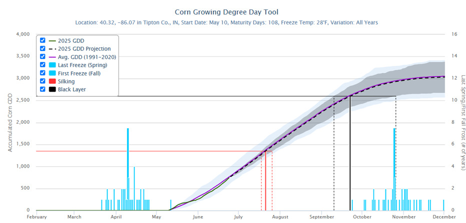
Figure 2. Corn growing degree days.
So, we’re hot and humid. Is this going to last? Forecast highs are expected to dip into the mid-to-upper 80s, extending into the first week of July. This offers a slight relief and more closely aligns with normal temperatures, similar to what we’ve experienced over the past few days. As for precipitation, the Climate Prediction Center expects elevated chances for above-normal precipitation. As for the rest of summer? Let me toss this over to our National Weather Service Northern Indiana friend, Kyle Brown.
Looking Ahead: July, August, September
Kyle Brown, NWS Northern Indiana
On the heels of meteorological Spring that could be described as mild and wet, the three-month outlook from the Climate Prediction Center (CPC) indicates above-normal temperatures are favored, paired with a slight lean to above-normal precipitation along the Ohio River. Equal chances for above- or below-normal precipitation are noted elsewhere in the state.
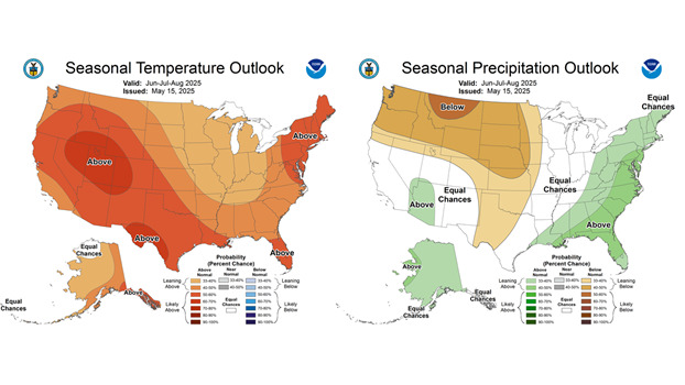
Figure 3. Seasonal temperature and precipitation outlook (June to August).
Since January 1, precipitation at Evansville is already over nine inches above normal as of mid-June. Evansville is on the western edge of the aforementioned above-normal precipitation outlook. According to the CPC, when compared to previous long-term model runs, the latest guidance was beginning to highlight the Ohio Valley for increased precipitation.
For the rest of the state, there is no clear signal for above-or below-normal precipitation. The short-term forecast favors dry conditions, with a strong ridge developing, which is expected to bring a stretch of hot, dry weather. For the remaining summer months, an active thunderstorm pattern or remnants of a tropical system could easily tip the scales to above-normal precipitation.
Based on consistent model guidance, there is a lean toward above-normal temperatures. One caveat noted in CPC’s discussion is that high soil moisture in parts of the Tennessee Valley raises uncertainty about the magnitude of the above-normal temperatures. With this in mind, moist soils in southern Indiana could be a factor in the extended temperature forecast.