More Heat on the Way July 11, 2025 - From Issue: 757 By: Beth Hall Read More One heat wave down, more to come. It is summer, though, so aside from expecting plenty of hot days, the primary concern is that reference (or potential) evapotranspiration (ET) significantly[Read More…] Article Categories: Vegetable Crops – General Article Tags: Climate and Weather
It’s a Hazy Shade of …. June June 13, 2025 - From Issue: 755 By: Beth Hall Read More Welcome to the start of Hurricane Season, which runs from June through November each year. Why would Indiana care about hurricane season? Certainly, by the time any hurricane might impact[Read More…] Article Categories: Vegetable Crops – General Article Tags: Climate and Weather
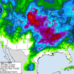
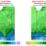
A Bit of Rain Coming Our Way May 16, 2025 - From Issue: 753 By: Beth Hall Read More The last few weeks have been on the drier side, particularly for northwestern and west-central Indiana (Figure 1). While temperatures have been seasonal, they are still gradually increasing as we[Read More…] Article Categories: Vegetable Crops – General Article Tags: Climate and Weather
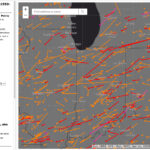
Tracking Tornadoes Over Time April 3, 2025 - From Issue: 750 By: Beth Hall Read More Indiana has already experienced several tornadoes this year, with more certainly to come. Of course, this is not unusual since Indiana is often considered on the far northeastern edge of[Read More…] Article Categories: Vegetable Crops – General Article Tags: Climate and Weather
A False Sense of Spring? March 14, 2025 - From Issue: 749 By: Beth Hall Read More It happens every year. A warm wave moves into the area, and I immediately get the urge to run to the nursery and start planting for the spring. Of course,[Read More…] Article Categories: Vegetable Crops – General Article Tags: Climate and Weather
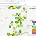
Expanding Precipitation Observations in Indiana February 20, 2025 - From Issue: 748 By: Austin Pearson, Beth Hall and Jacob Dolinger Read More How often have you heard that your neighbor received rain while you missed it? Precipitation is highly variable and has significant impacts on communities. Insufficient rainfall can cause drought and[Read More…] Article Categories: Vegetable Crops – General Article Tags: Climate and Weather
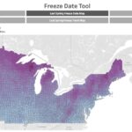
A Chill Is In The Air – Online Tools for Monitoring and Climatology October 17, 2024 - From Issue: 746 By: Beth Hall Read More While our daytime highs across the state have been in the upper 70s, our nighttime lows have been in the 40s. This is a great time to start thinking about[Read More…] Article Categories: Vegetable Crops – General Article Tags: Climate and Weather
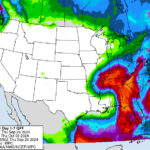
Rain Brought Some Relief, But Still Not Enough September 27, 2024 - From Issue: 745 By: Beth Hall Read More From September 19th through 25th, Indiana was fortunate to receive between a quarter inch to almost three inches of precipitation (Figure 1). This seemed to be a sight for many[Read More…] Article Categories: Vegetable Crops – General Article Tags: Climate and Weather
Cooler Temperatures should Settle in for a While August 8, 2024 - From Issue: 742 By: Beth Hall Read More After a period of hot and humid weather where heat indices reached triple digits in some locations, we welcome cooler than normal temperatures for the next several days. It is[Read More…] Article Categories: Vegetable Crops – General Article Tags: Climate and Weather
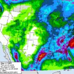
A Break Before More Rain July 25, 2024 - From Issue: 741 By: Beth Hall Read More Several weeks ago, Indiana received enough rain to eliminate drought across the state, leaving behind just a few counties in Abnormally Dry (D0) status. Fortunately, this week has been relatively[Read More…] Article Categories: Vegetable Crops – General Article Tags: Climate and Weather