La Niña Sticking Around Longer than Expected March 17, 2022 - From Issue: 700 By: Beth Hall Read More This past winter has been mild across Indiana. With the second La Niña winter in a row, there were expectations that the season would start of mild with some hope[Read More…]
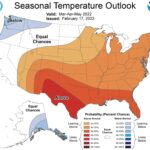
Above-normal Precipitation and Temperature Expected into Spring February 18, 2022 - From Issue: 699 By: Beth Hall Read More February has brought all kinds of precipitation to the state and now conditions are muddy if not flooded. Will this continue? The national Climate Prediction Center just released their 1-month[Read More…] Article Tags: Climate and Weather
Warmer Temperatures Expected Over Next Several Months October 21, 2021 - From Issue: 698 By: Beth Hall Read More The last several weeks have certainly been warmer than normal. Figure 1 illustrates just how warm with some parts of Indiana almost 7°F above normal over the past 30 days.[Read More…] Article Tags: Climate and Weather
Will La Niña Return Again this Winter? September 16, 2021 - From Issue: 697 By: Beth Hall Read More Last winter, earth was in a La Niña phase. While the relationships between El Niño – Southern Oscillation (ENSO) phases and Midwest climate are not strong, historically the La Niña[Read More…]
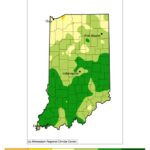
Drought Intensifying Across Central Indiana August 26, 2021 - From Issue: 696 By: Beth Hall Read More A lack of abundant precipitation over the past month has caused abnormally dry conditions to expand across Indiana this week with several counties in central Indiana intensifying to the Moderate[Read More…]
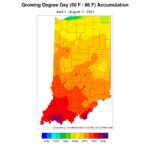
Dry Conditions Have Returned to Indiana August 12, 2021 - From Issue: 695 By: Beth Hall Read More Well, it was a nice 4 weeks with no drought or abnormally dry designated areas across the state. Unfortunately, the lack of rain over the past few weeks have led[Read More…] Article Tags: Climate and Weather
Early August Predicted to be Cooler and Drier than Normal August 2, 2021 - From Issue: 694 By: Beth Hall Read More After three consecutive weeks of Indiana being drought free according to the US Drought Monitor, it looks like next month is favored to be drier than normal and cooler than[Read More…]
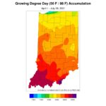
First Time Indiana is Drought Free Since Early June 2020 July 15, 2021 - From Issue: 693 By: Beth Hall Read More It is amazing to think that some part of Indiana has been in at least the Abnormally Dry category of drought on the US Drought Monitor for over a year.[Read More…] Article Tags: Climate and Weather
Storm Tracks Favor Some Parts of Indiana Skipping Others July 1, 2021 - From Issue: 692 By: Beth Hall Read More As we welcome July, Indiana seems to be in a very wet phase. Or, at least part of the state has been. The jet stream – a narrow band of[Read More…] Article Categories: Vegetable Crops – General Article Tags: Climate and Weather
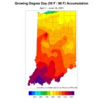
How Likely will Drought Develop or Worsen in Indiana? June 17, 2021 - From Issue: 691 By: Beth Hall Read More The news of the disastrous drought and extreme heat in the western United States (US) have local folks wondering if Indiana might be next. The latest release of the US[Read More…]