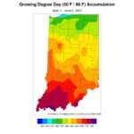
Updated Climate Normals Led to a Cooler May June 3, 2021 - From Issue: 690 By: Beth Hall Read More The month of May in Indiana was 2°F-4°F below normal across the state, based upon the new 1991-2020 climatological normals that were released last month. Climatological normals are roughly the[Read More…]
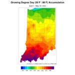
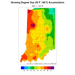
Growing Degree-day Accumulations Still Lag While Dry Conditions Linger May 20, 2021 - From Issue: 689 By: Beth Hall Read More Abnormally dry conditions are still lingering in parts of Indiana (Figure 1) with interest growing on how much the warmer weather might exacerbate the situation. Fortunately, the climate outlooks for[Read More…] Article Categories: Vegetable Crops – General Article Tags: Climate and Weather
More Observers Needed to Monitor Precipitation Across Indiana May 5, 2021 - From Issue: 688 By: Beth Hall Read More It seems the weather pattern may have shifted toward wetter conditions. Over the past week, Indiana has received over an inch of rain and the 7-day forecast is predicting at[Read More…] Article Categories: Vegetable Crops – General Article Tags: Climate and Weather
Does Snow in April Mean Global Warming is not Happening? April 22, 2021 - From Issue: 687 By: Beth Hall Read More This week, much of Indiana got to see some snow falling as we were hoping that winter weather was behind us. It is not unusual for some to ask when[Read More…]
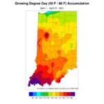
April Showers or Lingering Drought? April 8, 2021 - From Issue: 686 By: Beth Hall Read More March wrapped up as one of Indiana’s wettest (44th wettest out of 126 years) and warmest (16th warmest). It was marked by unusually warm days and then cool days. Was[Read More…] Article Categories: Vegetable Crops – General Article Tags: Climate and Weather
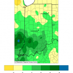
Dry Conditions Expected for the Rest of September September 17, 2020 - From Issue: 682 By: Beth Hall Read More The rain events northern Indiana saw last week may be the last significant precipitation seen in Indiana for the next several weeks. The US Drought Monitor has already place most[Read More…]
Cooler, Wetter Conditions Expected Over Next Several Weeks August 27, 2020 - From Issue: 681 By: Beth Hall Read More After the last several weeks of predominantly dry conditions, the national climate outlooks are finally showing confidence that temperatures should start shifting to cooler than normal and precipitation will be[Read More…] Article Categories: Vegetable Crops – General Article Tags: Climate and Weather
Monitoring Potential Evapotranspiration Across Indiana August 12, 2020 - From Issue: 680 By: Beth Hall Read More Rain moved across Indiana earlier this week, bringing much-needed precipitation to the northern counties. Unfortunately, the 30-day rainfall totals are still up to two inches below normal (Figure 1). The[Read More…] Article Categories: Vegetable Crops – General Article Tags: Climate and Weather
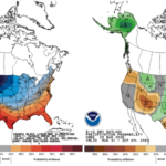
Indiana Climate and Weather Outlook July 30, 2020 - From Issue: 679 By: Beth Hall Read More On July 16th, the national Climate Prediction Center released the climate outlooks for August (Figure 1) and the August-September-October (Figure 2) period. Both outlooks are indicating a significant probability for[Read More…] Article Tags: Climate and Weather
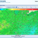
Reference Evapotranspiration Forecasts across Indiana July 15, 2020 - From Issue: 678 By: Beth Hall Read More The past 30 days have been met with warmer than normal temperatures in the northern counties and drier than normal conditions throughout most of the state (Figures 1 and 2).[Read More…] Article Categories: Vegetable Crops – General Article Tags: Climate and Weather